GeoLibre: a lightweight, cross-platform GIS for modern geospatial workflows
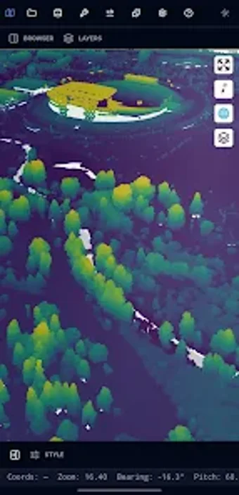
GeoLibre, developed by Open Geospatial Solutions, is a free, open-source GIS platform for visualizing, exploring, and analyzing geospatial data across environments. The app renders maps, terrain, and point clouds while providing a WebAssembly SQL workspace and AI-assisted plugins for natural-language geospatial tasks. It supports local file import alongside cloud-native streaming of large datasets, and is aimed at researchers, GIS professionals, educators, students, and developers seeking a privacy-aware, cross-device mapping workspace.
What GeoLibre is built to accomplish for research and instruction
GeoLibre targets data exploration and presentation by combining a modern web stack with GIS functionality. It is implemented with MapLibre GL JS and React, and supports story maps and animated camera tours for project presentation. The project is open-source under the MIT License and the developer maintains a plugin architecture so researchers and instructors can extend the workspace to match course exercises and lab workflows.
How GeoLibre handles very large geospatial datasets
GeoLibre uses a cloud-native streaming model to present gigabyte-scale vector and raster collections without forcing full local downloads. The app can stream large vector files, render 3D Tiles and point clouds with deck.gl overlays, and run spatial queries with embedded database engines such as
- DuckDB
- PostGIS
- Apache Sedona
Does GeoLibre run across mobile, desktop and notebooks consistently?
GeoLibre provides parity across browsers, desktop builds, and Android, and it is also available on iOS, Windows, macOS, and Linux. The Android edition requires Android 7.0 or later. Mobile includes a WebAssembly-powered geoprocessing toolbox and field collection tools for digitizing features and attribute tables, while the workspace can be embedded as a Python package inside Jupyter notebooks for reproducible analyses.
Who should adopt GeoLibre and what trade-offs to expect
GeoLibre suits technical users and open-source adopters such as researchers, developers, and GIS professionals who can manage plugins and data pipelines. The app emphasizes local processing and privacy, and it includes AI-assisted plugins for natural-language tasks. Expect a learning curve for traditional desktop GIS users and note that some very heavy geoprocessing workflows remain more practical on desktop builds.
GeoLibre is a practical choice for technically minded GIS users
GeoLibre is a capable option for researchers and educators who need a modern, extensible GIS workspace and who accept a modest learning curve. Some advanced analyses remain more practical in desktop environments, so teams should plan workflows that combine mobile exploration with desktop computation. For anyone prioritizing open-source toolchains and reproducible mapping workflows, GeoLibre provides a viable, long-term foundation.